James Bay Road website
The James Bay region of northern Quebec

Travel Guide to Hwy 109 - Amos to Matagami

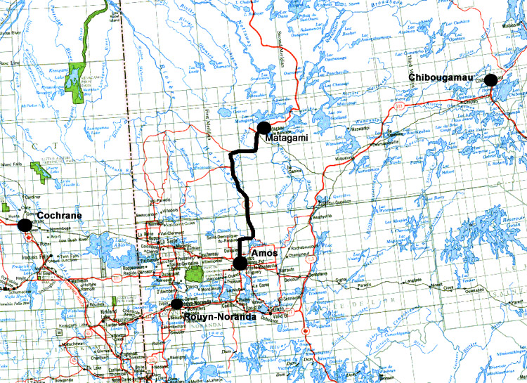
Hwy 109 is the main route used to reach the beginning of the James Bay Road. It's your first taste of the remote north as you head north. The starting point for this guide is Amos, Quebec, although Hwy 109 actually starts farther south in more settled areas.

UPDATED & REVISED SEPTEMBER 2005. Please note that hours of operation and availability of services may change.
Feel free to print this guide and take it along on your trip.


Km 41

Amos, the beginning of the section of Hwy 109 leading north to Matagami, 182 km to the north.
The last English language radio station (CBC) fades out north of Amos.

 
From Here to: Km Miles
Brisay 1308 811
Chibougamau (via James Bay Road & North Road) 878 544
Chisasibi 872 541
Eastmain 636 394
Matagami 182 113
Nemaska 573 355
Radisson 802 497
Wemindji 796 494
Waskaganish 521 323

Km 62

Last fuel until you reach Matagami (161 km)

Km 62

Rest area - tables, toilet, playground.

Km 73

Harricana River - last traces of settlement. From here the highway heads north into the remote wilds. Watch for logging trucks from here to Matagami.

Km 80 Major right-angle turn to the north (left).

Km 104

Municipality of James Bay boundary. The Municipality of James Bay covers an area of 350,000 square kilometers (135,136 square miles), making it the largest municipality in the world!

Km 117

Junction with bush road R1002, running east from Hwy 109.

Km 110 Emergency phone.
Km 114 Coigny River.

Km 118

Information panel: "A synthesis of ore-bearing structures".

Km 133

Paradise Lake. Emergency phone. The motel/lodge here is closed.

Km 133 Information panel: "What gives the emerald water its colour".

Km 158

Junction with bush road R1011 heading west to the mining area of Selbaie.
Rest area ("Cartwright"): toilet, tables, shelters. Nice viewpoint looking west.
Information panels: "The Matagami esker - surviving glacial action", "A trapping area in the Abitibi beaver reserve", "Animals and the Algonquins: respected partners in life".
Emergency phone.
Campground(?).

Km 165

Rest area: tables, shelters, toilets.
Km 195 Allard River. Highway maintenance compound (no services).
Km 197 Junction with bush road R1000, leading south.
Km 214 Noranda Mine, one of the major employers in Matagami.
Km 215 Matagami airport access road.
Km 218 Northern railway terminus (CN). This is as far north as the railway goes (no passenger service).

Km 223

Matagami, 1.5 km east from Hwy 109. Turn right for fuel and other services.
This is the beginning of the James Bay Road
, just outside of Matagami. This is the last town you'll see for 620 km (375 miles)!! Stock up on what you need for the trip, especially gas. There's only one gas station between here and the end of the road (at km 381 of the James Bay Road). For more info see the Matagami page.
The Shell station (the first one you encounter on your way in to town) is open 24 hrs, 7 days a week. There's a basic store here as well where you can get ice, some groceries, and other things.
 
From Here to: Km Miles
Amos 182 113
Brisay 1126 698
Chibougamau (via James Bay Road & North Road) 696 432
Chisasibi 690 428
Eastmain 454 281
Nemaska 391 242
Radisson 620 384
Wemindji 614 381
Waskaganish 339 210
 

Travel Info    Roads    Towns    Virtual Tours    Travelogues

 James Bay Road

The material on this page is copyright © by the original author/artist/photographer
This website is created, maintained & copyright © by Walter Muma
Please respect this copyright and ask permission before using or saving any of the content
of this page for any purpose

-- These other websites may also interest you --

Ontario Wildflowers   Ontario Trees & Shrubs   Ontario Ferns   Ontario Grasses   Ontario Insects
Mumart   World of Mosses   Wild Ontario   Trans-Labrador Hwy   James Bay Road   Rupert River   Moped Trip
Wildwood Survival   Wildwood Tracking   Leatherwood Trail   Tracker Trail   Earth Caretaker   Wildwood Canada

Thank you for visiting!