|
The Trans-Taiga Road is a gravel road that runs 666 km east
from near the top end of the James Bay Road. It
was built to access the various dams and generating stations that extend upriver
along the La Grande River.
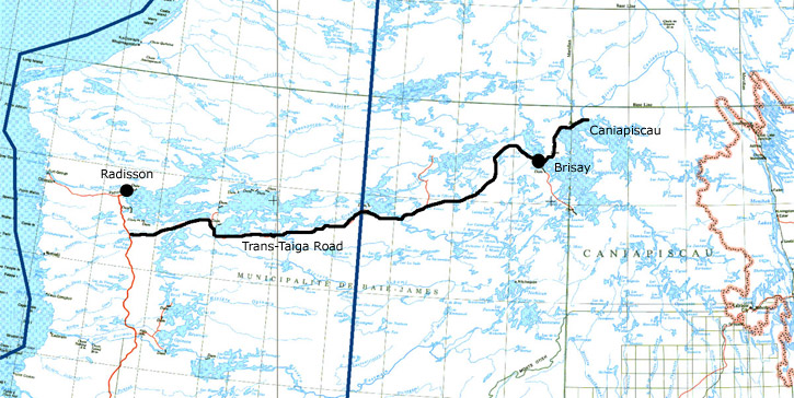
This is an extremely remote road, leading 666 km
east - almost to Labrador - with no settlements or towns aside from Hydro
Quebec's settlements for workers (not open to the public). At the far end you
will be 745 km from the nearest town! This is the farthest you can get from a
town on a road in North America! (Not counting the private Hydro Quebec towns
that are not open to the public). Along this road is also the
farthest north point you
can travel on a road in eastern Canada.
The road from Brisay (km 582)
to Caniapiscau is rougher and a 4-wheel
drive vehicle is recommended by Hydro Quebec. The main reason for this is the
very coarse gravel used for this road - there's large rocks littering the road
surface. However, I have heard from people who have driven this road in ordinary
passenger cars and they say it is fine. You do have to keep your eyes open for
the larger rocks though.
You should definitely travel this road only in a reliable
vehicle with good tires. It is not an overly rough road; passenger vehicles can
drive it, but it is gravel. Vehicle breakdowns here can be very costly. Flat
tires can be a serious (and expensive) incident if your tires are damaged. You
could be looking at having tires flown in on a non-scheduled flight - there are
no convenient "tire stores" up here! Please read
Driving the Trans-Taiga Road first.
Although there are no towns, there are a couple of outfitters
along the way that sell fuel and offer meals and lodging. Cell phones do not
work here.
Generally the scenery is fairly level, but this road is
definitely more interesting than the James Bay Road. For
most of the length it runs through taiga: spruce and jack pine forest, bogs,
rocks, and low hills. This is about all you'll see apart from birds and some
wildlife, the occasional cabin a short distance off the road, and Hydro Quebec
installations. I once saw a couple of wolves playing in the middle of this road.
|